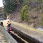

For any construction company or public work departments, having precise information about the underground utility lines is of utmost importance.
As the amazing network of roads, bridge and rails a city like Geelong have, the underground structure is the even more intricate arrangement with several utility pipes for water, gas, sewers, electricity, etc.
In such scenario, underground utility mapping has proven to be highly beneficial for gathering accurate and real-time data in the form of digital maps.
Without carrying out precise detection of what lies underneath, excavating into a utility line can cost time, money and energy. Organisations can’t depend on old maps, which provides off base and inadequate details of what they are investigating for; what they require is technology aided underground utility mapping services that are provided by several GIS companies.
Many GIS companies provide state-of-the-art utility detection services. Numerous organisations and government offices have found that utility mapping services give proactive, precise solutions for help in their development and planning projects, without stressing their monetary assets and squandering their time and money.
GIS companies specialising in utility mapping services offers the nitty-gritty and real-time underground utility mapping solutions. They create 2D and 3D maps and aid public work department in finding the underground utility lines effectively and precisely. From aiding you with a property development site to mapping the whole city, utility mapping services can be gigantically useful. GIS companies use CAD, GPS and GIS data conversion software to convert data into maps which are extremely valuable for several utility projects.
Listed below are some of the key advantages of GIS utility mapping in Geelong
- Real-Time Data AccessWith real-time GIS system, you can simultaneously analyse and display information from multiple sensors and devices. It permits you to track the progress of multiple projects at the same time. GIS gives a smart touch to underground utility mapping with various features including efficient information collection and processing, forecasting, collective intelligence, real-time alerts and distributed problem-solving aspect. It updates you with the exact idea of the underground situation, helping to take proper actions with right expertise and resources to tackle problem efficiently
- Enhances ResponsivenessNowadays, GIS facilitate a more streamlined way to work. It enables real-time information sharing between the field workers and utility service professionals with the tools needed to receive and record critical information. Its accurate and easily accessible database shortens disaster response time. It also reduces and eliminates paperwork, enabling better and faster decision making process.For instance, when a service request is received, the utility managers can track vehicles in the field to identify who is closest to the job site and re-route workers as needed. This results in employee’s productivity and enhances customer service.
- Saves MoneyGIS utility mapping offers better work efficiency which ultimately results in cost reduction. With a centralised database access, the field staff can efficiently retrieve accurate information from the remote location. GIS utility mapping services can save your time, money and energy, right from location underground property requiring repairs and maintenance to developing digital work orders and inventory tracking.It helps to alleviate the necessity of developing prints, manual report preparation, input details, reviewing daily schedules, using paper maps to plot routes and much more. GIS implementation automates certain tasks saving dollars spent on preventative maintenance, repairs and mandatory replacements.
- Managing Assets More EasilyWith the help of GIS properly arranged geographic data of underground utilities, the technicians on the field can easily access information related to maintenance, replacement, repairs and inspection. GIS with a location-based tracking feature allows a user to trace and share location data precisely reducing the troubleshooting time. Access to real-time information, public work departments can easily manage all the assets which only reduce the repair and replacement services cost but also enhance decision making and precision in work.
- Aids in Operational PlanningGIS has become essential in government and many public work departments. It offers a visual outline for conceptualising, understanding, and action. An essential feature of GIS is its ability to convert old datasets into geo-enabled information which is accessible by multiple users anytime, anywhere.
- Speed Decision MakingOne of the major advantages of GIS is the capability to offer precise visualisation through mapping. GIS can consolidate land information like zoning, permitting, parks and developments with standard road maps and aerial views. This mapping ability allows staff to show essentially more valuable data for official city meetings by focusing in on simply the components required for consideration. This offers better understanding resulting in speed decision making.
It is highly essential that the people involved in particular projects understand the information properly for a better decision making. GIS facilitates the public work departments and the perse on-site team to work in close collaboration on the huge infrastructure and property development projects. This alleviates the access the time and energy spent on information sharing. It also makes certain that the entire team uses the same tool to interpret the same real-time information, strengthening the understanding and productivity.
GIS is transforming the way public work departments manage the utilities. It provides immense help in making apt plans and designs for damaged utility lines. It saves many government organisations and public work departments by preventing delays and expenditures. With efficient GIS utility mapping in Geelong, not only a company can complete projects on-time but it also saves costs and makes dynamic use of assets.