Ground Penetrating Radar Imaging in Geelong
Are you an engineering company? Are you thinking of any new plant to set up? Do you need to check the subsurface before finalising the plant structure?
Are you an independent or government archaeologist? Do you need to study the soil and collect the data?
Are you an environmentalist? Do you need to study the condition of the soil and make a report to take any informed decision about any structure or set up?
If the answers of the above questions are in affirmation, Ground Penetrating Radar (GPR) imaging service provided by GeoScan can be your ideal solution.
What is Ground Penetrating Radar (GPR)?
In simpler words, it is a geophysical technique to image objects, changes, voids or cracks or any other activity being taken place under the surface. It is widely used to image rock, soil, ice, fresh water, pavements and structures. The areas that can benefit the most by Ground Penetrating Radar imaging include engineering, geology, environmental studies, including, archaeology.
How GeoScan leverages this technique?
GeoScan is efficient to leverage this scientific technique to the fullest. We have the equipment that facilitates electronic depth readings. In order to take full advantage of Ground Penetrating Radar imaging technique, we have the latest equipment that:
- is safe and do not get affected by any interference
- is not radio active
- is operated by electromagnetic signals
- omits low milliamp signals
- does not harm adjacent areas or soil
Read more about how we do our work here in our FAQs.
Why take GeoScan's Ground Penetrating Radar services?
Look at our testimonies and you would know instantly why GeoScan's Ground Penetrating Radar imaging services in Geelong are admired by its clients. Some of our clients include:
- Local Government Authorities
- Civil Engineering
- Surveyors
- University and TAFE Colleges, Schools
- Architects, Hospitals
- Petroleum Industries
- Road works and Footpath excavations
- Excavation and trenching
- Landscaping and Irrigation Contractors
- Plumbing and Electrical
- Fencing Contractors
- Arborists (tree surgeons)
- Road Authorities
- Pipeline laying contractors
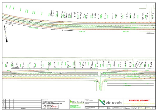
GPR Object Mapper & Survey - Example
Our GPR equipment has a built in GIS mapping system called object mapper. When conducting a ground investigation we can map and GIS survey at the same time to produce images : - (as attached below)
- Object Mapper Grid System On The Left
- Data Image Survey during surveyed Ground Investigation process - On The Right
- Example Of A Sports Ground GPR Scan Profile Indicating 2 Lengths Of The Field Scanned
While providing Ground Penetrating Radar services in Geelong and regional Victoria, GeoScan also leverages its unique device called the time triggering method. This method allows us to decipher ground disturbances taking place beneath the surface due to water leaks or any other subsurface instability.
GeoScan is not only expert in deciphering these movements.With the object mapping and GIS surveying using GPR equipment, we also produce a comprehensive report on our findings.
Wide Range of Scanning:
Apart from already mentioned areas, there are other areas in which Ground Penetrating Radar imaging can be immensely helpful. They are:
- Underground utilities (non metallic services)
- Underground storage tanks
- Buried concrete slabs (reinforced and non reinforced concrete)
- Footpath and road subsurface investigation
- Concrete footing investigation
- Buried pit covers
- Valve boxes and taps
- Underground voids or disturbances
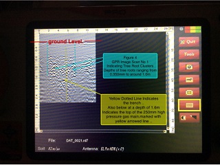
- Tree root assessment
- Sub surface investigation such as detecting presence of rock, bedrock, soil layering and changes in soil density
- Location of underground voids and ground disturbance
What are you waiting for then? Call GeoScan right now and know more about Ground Penetrating Radar imaging in Geelong and regional Victoria.