With the rapid urbanisation, industries have started relying on more complex and larger utility networks underground. You'll be surprised to know that utility surveying has been with us since the beginning of the 20th century. From underground utility locating and mapping, GPR to buried utility detection, utility surveying has become an essential step to identify and map buried infrastructure.
In the early years, people used electromagnetic locator - the very first tool to detect utility maze of pipes and cables underneath the ground. Since its first investigation, the EM field detection theory hasn't been changed.
Found in the 1970s, electromagnetic (EM) locator has evolved drastically. Earlier, it used to be a needle-based analogue display whereas, with the advancement in technologies, modern EM locators come with digital display and are more efficient, compact and user-friendly. It now also provides important data like direction, current and strength of the signal.
A Brief History About Utility Surveying
In the early days of utility location services, surveying was done with the help of the only EM locator available in the market and few handy tools. Fibre optics weren't so much popular and thus locators were only locating metallic utilities. Similarly, GPS technology wasn't used widely as it was costly and even their stations were far. The data of underground utility locating was scaled on paper.
Earlier, utility location services provider has simple rules, lift and trace every possible thing to get the required data and leave no room for errors. These still remain the key points of performing any underground utility locating survey. Over the years, the locator has changed while the theory and the methodology remain the same.
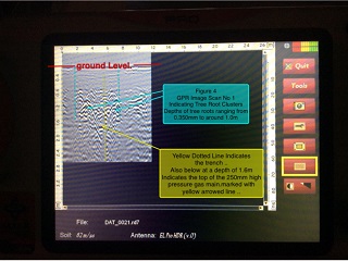
In the early 90s, a piece of new equipment was invented – GPR, ground-penetrating radar systems which can see underneath the ground. This is where the use of utility locators comes to an end. However, many utility location services provider still prefer to use both GPR and cable locators to get the most precise and real-time data.
Redefining Underground Utility Locating & Surveying
 With development growing at a rapid pace, utility location and survey is becoming complicated with every passing day. In a very short time, we have come a long way from hard copies to digital data. That's not all; even GPS/GNSS is no longer use. Instead, point cloud data is combined with 3D modelling of the underground utilities to get the accurate location of the utilities.
Nowadays, utility location services provider uses GPR and electromagnetic locators to offer a combined solution of locating, collecting and mapping data. The best part is, the data is provided instantly based on the client's requirement.
Top 10 Utility Surveying Practices You Need To Know
The thumb rule of a successful underground utility locating and surveying is to follow the below mentioned ten practices that are tried and tested over the last four decades. Let's have a look:
- Make certain that your staff holds experience and undergoes pre-requisite training to conduct the underground utility locating and survey competently that exceeds the client's expectations.
- Ensure that the client specifies their requirement and expectation in writing.
- Be prepared. Connect with your client and other companies to gather and understand all the statutory information, including, legends, scale, clarity, etc.
- Collect topographical survey to validate your results.
- Perform an initial inspection and do a visual survey with the help of statutory records. Before you use any locators, inspect old records, surface features, and overhead lines and map the things accordingly.
- Perform electromagnetic survey methodically
- Correctly position your GPR device. Remember, this is not a replacement of cable locator as it is also bound by physics rules and laws and can impact the performance.
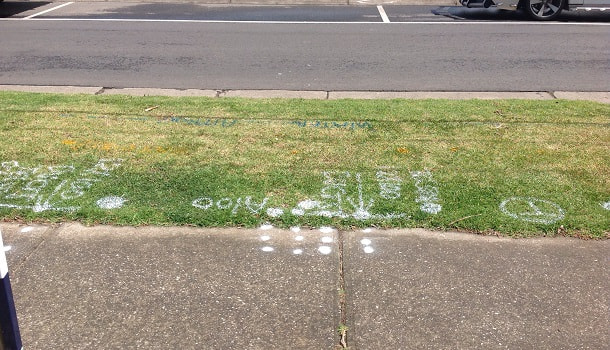
- Use an effective marking system which is easy to understand and as per the guidelines.
- Take an efficient, accurate and methodical method to collect your data and collect photo/video as back up.
- The data is ready to send to your clients.
Conclusion:
Underground utility locating and surveying is and will remain an integral part of any excavation project. Staying up-to-date with the latest inventions and technology is essential to perform a survey. Even a minor error in data can result in major consequences, which could have been easily avoided. Getting an insight into what's underneath ground can help perform safe excavation without causing any damage and delays.